


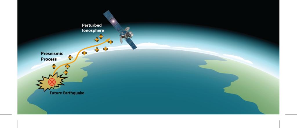
Earthquakes, one of the most destructive natural disasters on Earth, have terrified people throughout history, leveled cities, and changed the fate of countless civilizations. Even today, despite advanced seismology technologies, we cannot definitively say, “An earthquake will occur on this day and at this time.” However, scientists have opened a new front to bring this possibility a little closer to reality: the sky. Yes, researchers who never tire of listening to what lies beneath the earth have now turned their eyes to space, especially the ionosphere. Because stress deep within the earth may sometimes be sending signals to the sky. And if we can read these signals, perhaps we can decipher the language of earthquakes. The ionosphere is an electrically charged layer in the Earth’s atmosphere, extending from approximately 60 kilometers to 1000 kilometers, where sunlight ionizes gases. It reflects radio waves, affects GPS signals, and is the setting for what we call space weather phenomena. This layer has the potential to act like a sensitive record book for electrical and magnetic fluctuations triggered by massive stresses in the Earth’s crust. Fractures and friction in the Earth’s crust before an earthquake can lead to an accumulation of electrical charges, which in turn cause changes in the electrical field in the atmosphere and consequently measurable anomalies in the ionosphere. This idea was initially considered quite speculative, but over the years it has been supported by serious measurements and statistical analyses.
For example, studies conducted before the 2011 Tohoku (Japan) earthquake (Mw 9.0) detected an abnormal increase in ionospheric total electron content (TEC) values measured by GPS stations approximately 40 minutes before the earthquake. In an analysis by Hayakawa and colleagues from Hokkaido University, GPS network data over Japan showed a TEC increase of 30–50% above normal values 40–50 minutes before the earthquake. Similarly, TEC anomalies were recorded at GPS stations around the Indian Ocean before the 2004 Sumatra-Andaman earthquake (Mw 9.1). China’s CSES (China Seismo-Electromagnetic Satellite) reported anomalous fluctuations in electron density in the lower ionosphere days before the Mw 6.0 earthquake in the Sichuan region in 2019. Such concrete data support the idea that stress fields forming in the Earth’s crust before an earthquake can disrupt the electrical structure of the atmosphere, causing measurable anomalies in the ionosphere. This forms the basis for studies aimed at understanding this relationship statistically. Similar anomalies have been reported in different regions before major earthquakes. This data has whetted the appetite of researchers.
Is it possible to develop an early warning system by combining multiple parameters? This is where space technologies come into play. In addition to classic large satellites, there are now low-cost, small but functional nanosatellites. Thanks to these cube-shaped satellites, smaller than a shoebox, it is possible to monitor the ionosphere much more frequently and in detail, both globally and regionally. For example, the European Space Agency’s Swarm satellites can map the Earth’s magnetic field and ionospheric behavior in detail by measuring magnetic and electric fields in the ionosphere. China’s CSES (China Seismo Electromagnetic Satellite) mission was launched with a direct focus on detecting electromagnetic anomalies that precede earthquakes. Japan also has nanosatellite experiments like QuakeSat. The goal is to identify signals that could be earthquake precursors in the chain extending from the Earth’s crust to the ionosphere.
In projects like these, various sensors are used to detect anomalies in the ionosphere, such as GPS signal delay measurements (TEC analysis), electromagnetic wave measurements, and magnetic field changes. However, measuring the ionosphere alone is insufficient; solar activity, geomagnetic storms, and cosmic rays can also create similar changes in the ionosphere. This is why artificial intelligence and big data analysis are at the heart of these studies. Scientists are developing specialized algorithms to distinguish which signals are precursors to earthquakes and which are merely space-weather related by examining thousands of samples. The concept of a “multi-parameter approach” is gaining prominence in this field: ionospheric data, measurements of the Earth’s magnetic field, seismic activity, and even underground gas emissions are combined to attempt risk estimation.
Of course, these studies are still in their infancy. Does a signature always form in the ionosphere before an earthquake? Or, if it does, can we see this signature with the same precision everywhere? These are questions that need to be answered. While some studies find anomalies in the ionosphere before every major earthquake, others report weaker or inconsistent correlations. There’s also the issue of timing: If you see an anomaly, does that mean an earthquake will occur a day later or a week later? How exactly do you narrow down the region? All these are huge riddles to solve. But the scientific community won’t give up. In recent years, thanks to small satellites that are planned or already in orbit, monitoring the ionosphere in real time has become easier. Next-generation nanosatellites are now equipped with more advanced sensors, transmitting data to the cloud and providing it instantly to the global research community. In addition, thanks to the extensive GPS networks established worldwide, ground-based receivers can also map the three-dimensional structure of the ionosphere. When all this data is combined, it may one day even be possible to see a real-time “Earthquake Risk Map” like Google Maps. Imagine receiving a notification on your mobile phone saying, “Seismic risk has increased in your area within the next 48 hours!” That’s the scientists’ dream.
Of course, even when such a system is established, it won’t be 100% accurate. Because the behavior of the Earth’s crust is incredibly complex. However, it could provide a significant advantage compared to the current situation. For example, the ability to provide warnings a few days in advance, shutting down critical infrastructure, preparing hospitals, and raising public awareness could save thousands of lives. Countries in earthquake zones, like Japan, take this issue very seriously for this reason. Similar research programs are also being conducted in China, India, the USA, and Europe. As a result, predicting earthquakes by looking at space has ceased to be a science fiction fantasy and has become a scientific field of endeavor. Nano-satellites listening to the whispers of the ionosphere may well be the earthquake prophets of the future. We are still at the beginning of the journey, but hope is great. Earthquakes may be inevitable, but their consequences can be prevented. And perhaps the thing that will help us most in this regard will be human curiosity and determination, which never stops looking at the sky. Hence, this is also one reason why studying aerospace engineering is becoming more popular than ever.
Summary
- Ionosphere as a Potential Earthquake Indicator: The ionosphere, a charged layer of Earth’s atmosphere, may reflect electrical and magnetic signals caused by crustal stress, offering a possible way to detect earthquakes before they occur.
- Evidence of Ionospheric Anomalies Preceding Major Earthquakes: Studies have recorded increased ionospheric electron content and other anomalies minutes to days before significant earthquakes, suggesting a potential link between ionospheric signals and seismic activity.
- Advances in Space Technology for Earthquake Prediction: Miniaturized satellites like nanosatellites and missions such as ESA’s Swarm and China’s CSES improve real-time ionospheric monitoring, enhancing our ability to detect earthquake precursors globally and regionally.
- Challenges and Tools in Detecting Earthquake Precursors in the Ionosphere: While sensors measure ionospheric changes, differentiating earthquake signals from space weather effects requires sophisticated artificial intelligence and multi-parameter data analysis.
- Future Prospects and Limitations of Space-Based Earthquake Prediction**: Although still in early stages, combined data from satellites and ground networks could enable early risk maps, providing critical warnings and saving lives, even if predictions are not yet perfectly accurate.


Add Comment